June 27, 2018
Geohazards Bundle

Alberta flood season is here. So is wildfire season. Unseasonable heat across Western Canada has caused mountain snow-packs to quickly melt and swell rivers across floodplains. The same heat has dried out forest and brush causing fires across British Columbia and Alberta. It can be difficult to monitor every geohazard threat to your pipelines, but it is crucial to do so.
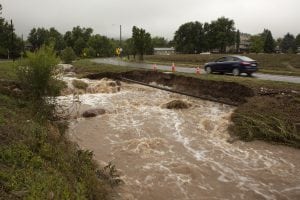
HydroFlow, Cenozon’s latest innovation, combines real-time stream flow data with historical data to provide operators with an accurate picture of what is happening at their pipeline water crossings.
Historical high stream flow trends may warrant a full-blown geo-technical survey, yet nominal historical conditions might mean that an inspection can be deferred. HydroFlow can inform you what conditions your water crossing have been exposed to – empowering you to optimize your inspection schedules, meet compliance, and save money.
WildFire combines pipelines schematics with up-to-date information on wildfire locations.
It has never been easier to visualize where your pipelines are, where the 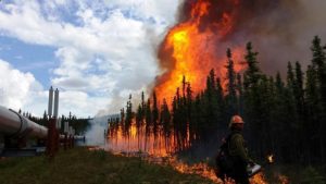 wildfires are, and exactly what kind of wildfire you are up against. Receive a notification if a wildfire is in vicinity of your pipelines and facilities and assess if further action is required to mitigate risk and to ensure public and employee safety.
Is it active? Under control? Out of control? With the WildFire app you can see the area burned, amount of manpower fighting the fire, even the amount of aircraft, bulldozers, skidders and pumps assigned to controlling the fire- all overlaid with a map of where your pipelines are, what they carry, and if they are active, discontinued, or abandoned.
The Geo-Hazards Bundle Offer
Cenozon is bundling HydroFlow and WildFire together. Sign up for HydroFlow and receive WildFire free for the rest 2018!